        |
The Kelly Mansion This piece of Cypress Hills history was triggered by a submission from Noreen Lavan. Noreen has done some exceptional genealogical work on the Kelly family,
and I was able to assist her with my experience researching the Cypress Hills area. For some irony, Noreen's great-aunt Mildred Kelly, who passed down some of this information, was my first grade teacher at P.S. 108! |
||
|
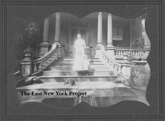
The Kelly Mansion Noreen sent this picture of the mansion, with some of her ancestors posed on the steps. We know they moved into the house in 1902, so this picture dates somewhere between 1902 and 1910. Noreen's great-aunt, Mildred Kelly, provides some background: "... a mansion which was in the middle of 4 square blocks, Crescent to Pierce Place and Atlantic to Fulton Street. It had a white fence all around it and had an apple orchard surrounding the house. Card parties and socials to raise money for Blessed Sacrament Church were held in the ballroom. " | |
|
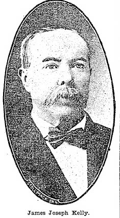
Who was Kelly? The Kelly was James J. Kelly, an Irishman who emigrated to the U.S in 1869. This picture comes from an obituart which ran in the Eagle on September 10, 1902. Kelly owned and operated the last 'ropewalk' in the East New York area. Ropewalks were used to manually manufacture ropes, and became defunct once rope-making machines were perfected. The ropewalk closed in 1899 according to the article. The mansion was purchased in 1902. The Kelly family was very prominent in their support of Blessed Sacrament, hosting fund-raising parties at the mansion and on the grounds. | |
|

|
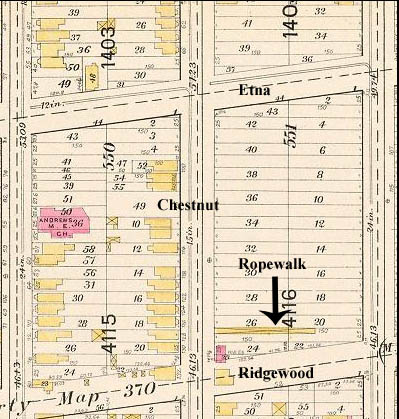
The Ropewalk Ropewalks are very long, narrow buildings. Workers move carts along tracks while the rope is spun. On the left, I managed to find an 1898 map with the location of Kelly's ropewalk. It appears to be the only building on the block surrounded by Chestnut, Euclid, Ridgewood and Etna. The picture on the right is NOT East New York, but an interior shot of a typical ropewalk in those days. The ropewalk did not appear on the 1886 maps, so it appears it was only around for about 10 years. |
|
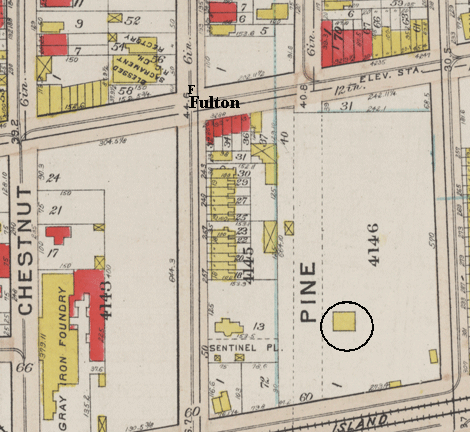
Where was the mansion located? Noreen's great-aunt, Mildred Kelly noted the house was located between Fulton Street, Crescent Street, Atlantic Avenue, and Pierce Place. Bear in mind Pine Street between Fulton and Atlantic Avenue did not exist in those days, so I suspect Pierce Place, a street name I have never come across on any map or article relating to East New York, may have been a local name for the path that would become Pine Street. In this 1908 map I have circled what we believe was the house. Note in the upper left the original Blessed Sacrament building, and its easy to see how the proximity of the mansion made it convenient for hosting church events. | |
|
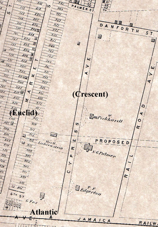
Who built the mansion? Noreen's ancestors indicated the manions may have been built by a southerner named "Mackey'. I attempted to wind back the clock by consulting a map from 1873. At this point in time the property was owned by the Lichtenstien family. I uncovered an article from 1869 that indicated the property was considered for purchase by the City of Brooklyn to locate the Boys' Truant Home. (The City eventually chose the land where Franklin K. Lane sits today.) The article describes the property as 7 acres in size, which means means it stretched all the way north, up to where Etna Street is today. Note there are 2 houses on the land south of Fulton. The Leichtenstein house is gone by the 1886 maps, and only the house belonging to "Fox" remained, which we believe was the Kelly mansion. Oddly, Leichtenstein does not appear on the 1860 or 1870 census. He was a wealthy Prussian merchant, and it is possible this was just a summer estate. So we believe the house was there in 1873, but we can't yet determine who built it and when. | |
|
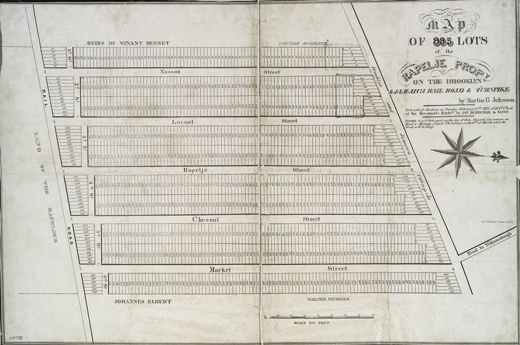
Who sold the land? If you're curious why the left side of the map is so developed while the right side remained undeveloped, it has to do with the original farm plots. This map was created in 1835. I believe it was done by Martin Johnson for John Pitkin, who had purchased part of the Rapalje farm and had it divided into 995 building lots. The border splitting the block between Chestnut and Crescent Street represented the border between Rapalje's farm and Johannes Eldert's. Johannes willed the property to his sons, and I believe his descendants do not sell this portion of the farm until the 1860's. Note that in the original Pitkin maps, Crescent Street was known as "Judson Avenue". It was later named "Cypress", and re-named Crescent in 1887. To date I have not been able to determine to whom the Eldert family sold the property. | |
|
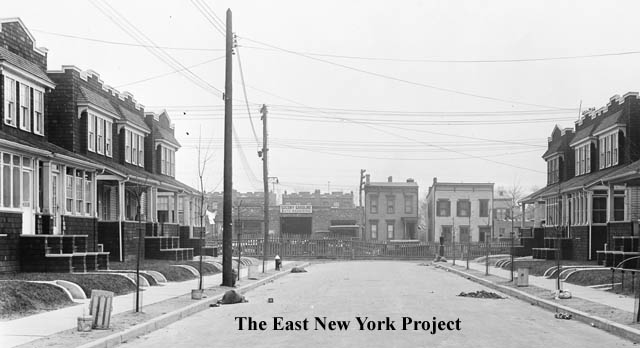
Pine Street, 1923 This image from the Brian Merlis archives shows the developed land in 1923. The view is south towards the ground-level LIRR tracks on Atlantic Avenue. Maps from 1916 indicate that the mansion was gone, but the property was still not developed. So though we have rough timelines on when the house appeared and later disappeared, we are still missing a lot of details that we hope to some day uncover. | |